Enog Geographic Information Technology
(Centre for Integrated Built-Environmental Consultancy & Research)
Research & Publications

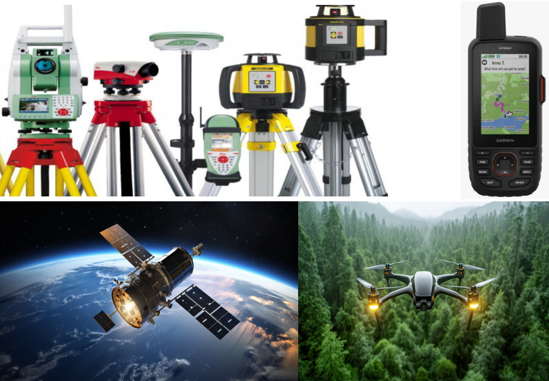
Considering the high level of human-environment interactions, causing land and environmental degradation in the built and natural environments, our research adopts the integrated research approach within a multidisciplinary context. Through scientific innovation, the integrated research approach combines natural, social, and spatial sciences to investigate the real-world problems associated with human-environment interactions. In doing so, our research integrates Geographic Information Technologies (GIS, GPS, Remote Sensing, etc.) and other Built-Environmental Technologies with quantitative and qualitative survey-based data for the purpose of contributing to environmental sustainability in particular and sustainable development in general. Our research findings are published as open-access in international Journals.
We also seek research projects from public and private institutions, agencies, and companies. Additionally, we develop research projects and seek funding from research funding organisations. Our research projects are being implemented through collaborations with public and/or private institutions, including universities and research institutes.
Furthermore, we are open to supervising research projects at all levels, including Bachelor’s and Master’s Theses and PhD Dissertations. We organise lectures on Research Methodologies, including Scientific Writing, Academic Writing, Scientific Presentation, and PhD Disputation.
Research Groups
Applied Geoinformatics & Geomatic Engineering Research Group
The primary objective of the Applied Geoinformatics & Geomatic Engineering Research Group is to promote the innovation and use of advanced geospatial technologies to address practical challenges in areas such as environmental management, urban development, natural resource utilization, infrastructure planning, and disaster risk mitigation. The group is dedicated to connecting academic research in geomatics with real-world applications that benefit communities, industries, and policy-makers.
Applied Geoinformatics in Urban & Regional Development Planning Research Group

The central aim of the Applied Geoinformatics in Urban & Regional Development Planning Research Group is to utilize geospatial technologies and spatial analytical methods to promote sustainable urban growth and equitable regional development. The group emphasizes the incorporation of geoinformatics into planning strategies to optimize land use, strengthen infrastructure systems, build environmental resilience, and ensure fair distribution of resources. Through a combination of research, technological innovation, and interdisciplinary collaboration, the group seeks to deliver data-informed approaches that support effective policy decisions, advance smart city development, and improve living conditions in both urban and rural communities.
Applied Geoinformatics & Environmental Sustainability Research Group

The primary aim of the Applied Geoinformatics & Environmental Sustainability Research Group is to apply geospatial technologies and analytical approaches to advance the conservation, management, and sustainable utilization of natural ecosystems and resources. The group emphasizes the use of tools such as GIS, remote sensing, and spatial modeling to track environmental changes, analyze the dynamics between human activities and the environment, and support strategies for climate adaptation and mitigation. Through collaborative, interdisciplinary research, the group seeks to deliver practical knowledge that informs sustainable policy-making, strengthens ecological systems, and supports global efforts toward environmental sustainability.
Applied Geoinformatics & Environmental Impact Assessment Research Group
The primary aim of the Applied Geoinformatics & Environmental Impact Assessment Research Group is to enhance the application of geospatial technologies in assessing and addressing the environmental impacts of development projects and land use activities. The group is dedicated to incorporating tools like GIS, remote sensing, and spatial analysis into Environmental Impact Assessment (EIA) processes to improve the precision, effectiveness, and clarity of environmental evaluations. Through practical research and cross-disciplinary partnerships, the group seeks to facilitate informed decision-making, reinforce environmental regulations, and encourage development practices that reduce ecological disruption and support long-term sustainability.
Applied Geoinformatics & Heritage Impact Assessment Research Group
The primary objective of the Applied Geoinformatics & Heritage Impact Assessment Research Group is to apply advanced geospatial technologies for assessing and managing the effects of development activities and environmental changes on cultural and natural heritage sites. The group emphasizes the use of GIS, remote sensing, and spatial analysis tools to aid in the documentation, preservation, and sustainable stewardship of heritage resources. Through collaborative, interdisciplinary research, the group strives to deliver precise evaluations that support heritage conservation policies, promote responsible development, and protect cultural heritage for future generations.
Applied Geoinformatics & Agricultural Sustainability Research Group
The primary objective of the Applied Geoinformatics & Agricultural Sustainability Research Group is to utilize geospatial technologies and spatial analytics to advance sustainable farming practices and improve food security. The group concentrates on employing tools like remote sensing, GIS, and spatial modeling to track crop conditions, enhance resource efficiency, evaluate land suitability, and reduce environmental impacts. Through innovative research and partnerships, the group strives to enable data-informed decisions that promote resilient agricultural systems, protect natural resources, and support enduring agricultural sustainability.
List of publications
Isimah, M. O., Chukwurah, G. O., Enoguanbhor, E. C., Agholor, H., Nwanisobi, G., Nwafor, I. F., Nnoli, C. I., 2025. Geospatial assessment of the effects of cassava mill effluent on the environment in Ika North East, Delta State, Nigeria. Environ. Monit. Assess., 197, 803. https://doi.org/10.1007/s10661-025-14238-5
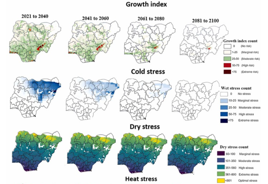
Ibrahim, E. S., Nendel, C., Ajayi, A. E., Berg-Mohnicke, M., Schulz, S., 2005. Simulating and mapping the risks and impact of fall army worm (Spodoptera frugiperda) and white grub (Holotrichia serrata) in maize production outlooks for Nigeria under climate change. Agriculture, Ecosystems and Environment, 385, 109534. https://doi.org/10.1016/j.agee.2025.109534
Agunbiade, M. B., Menares, E., Fotang, C., Jallow, M., Camara, F., Enoguanbhor, E. C., Shittu, W. A., Ogada, D., Birkhofer, K., 2025. Amount of Organic Waste Affects the Composition and Interactions of Vertebrate Scavengers at Gambian Slaughterhouses. African Journal of Ecology, 63:e70045. https://doi.org/10.1111/aje.70045
Chukwurah, G. O., Okeke, F. O., Isimah, M. O., Enoguanbhor, E. C., Awe, F. C., Nnaemeka-Okeke, R. C., Guo, S., Nwafor, I. V., Okeke, C. A., 2025. Cultural Influence of Local Food Heritage on Sustainable Development. World, 6(1), 10. https://doi.org/10.3390/world6010010
Enoguanbhor, E., Enoguanbhor, E., Chukwurah, G., Isimah, M., John-Nsa, C., Oloruntoba, E., Fotang, C. Ngwator, T., Yangni, G., Oladosu, O., Agunbiade, M., 2024. Assessment of conformity to demarcated environmentally sensitive areas in land use plans: The case of Abuja, Nigeria. Town and Regional Planning, 84, 58-71. https://doi.org/10.38140/trp.v84i.7985
Enoguanbhor, E. C., Enoguanbhor, E. A., Chukwurah, G. O., Oloruntoba, E. O., Edo, I., John-Nsa, C. A., Fotang, C., Yangni, G. N., Oladosu, O. A., Agunbiade, M. B., Njunda, F. T., Achenui, R., 2024. Spatial Interactions of a City-Region Using GIS and Survey-based Data. East African Journal of Interdisciplinary Studies, 7 (1). https://doi.org/10.37284/2707-5303
Enoguanbhor, E. C., Enoguanbhor, E. A., Chukwurah, G. O., Oloruntoba, E. O., John-Nsa, C. A., Fotang, C., Yangni, G. N., Oladosu, O. A., Agunbiade, M. B., Njunda, F. T., 2024. The City-Region Formation Patterns and Urban Spatial Density Using GIS-based Data. East African Journal of Environment and Natural Resources, 7 (1). https://doi.org/10.37284/eajenr.7.1.2105
Enoguanbhor, E. A., Chukwurah, G. O., Enoguanbhor, E. C., Isimah, M. O., Kosun, A. E. O., Ewurum, N. I., Albrecht, E., 2024. Underlying Anthropogenic Driving Factors of Forest Landscape Degradation in the Kilimanjaro World Heritage Site, Tanzania Using Survey-based Data. Nature Environment and Pollution Technology. 23(2), 1115-1122. https://doi.org/10.46488/NEPT.2024.v23i02.045
Enoguanbhor, E. A., Enoguanbhor, E. C., Edo, I., Albrecht, E., 2024. Comparing Spatial Determinants of Forest Landscape Degradation based on Experts’ Perceptions and GIS Analysis: The Case of Kilimanjaro World Heritage Site, Tanzania. East African Journal of Environment and Natural Resources 7 (1), 49-58. https://doi.org/10.37284/eajenr.7.1.1674
Ibrahim, E. S., Nendel, C., Kamali, B., Gajere, E. N., Hostert, P., 2024. Predicting Potato Diseases in Smallholder Agricultural Areas of Nigeria Using Machine Learning and Remote Sensing-Based Climate Data. PhytoFrontiers TM, 4(2), https://doi.org/10.1094/PHYTOFR-10-22-0105-R
Ibrahim, E. S., Chiroma, J. T., Abubakar, M. K., Ojih, S. A., Waziri, E. S., Daffi, R. E., Yenne, E., 2024. Spatial modelling of present and future groundwater potentials in Nigeria; towards a sustainable water demand and supply. Sustainable Water Resources Management, 10:137. https://doi.org/10.1007/s40899-024-01107-1
Chukwurah, G. O., Aguome, N. M., Isimah, M. O., Enoguanbhor, E. C., Obi-Aso, N. E., Azani, N. U., Nnamani, O. C., 2024. Community Perception on the Effect of Cultural Livelihoods on the Environment in Kogi State, Nigeria. Nature Environment and Pollution Technology, 23(4), 2325-2334. https://doi.org/10.46488/NEPT.2024.v23i04.036
Chukwurah, G. O., Aguome, N. M., Nwafor, I., Azani, N. U., Evangeline, A. N., Enoguanbhor, E. C., Ugwu, D., 2024. Environmental Implications of Sculpture Landscape in Ancient Cities with Reference to Enugu, Nigeria. Asian Journal of Water, Environment and Pollution, 21(5), 57-63. https://doi.org/10.3233/AJW240060
Enoguanbhor, E. Chukwurah, G., Enoguanbhor, E., John-Nsa, C., Isimah, M., Edo, I., Achenui, R., Matemilola, S., Fotang, C., Ijioma, U., Ibrahim, E., 2023. Evaluating urban land-use demarcation and implementation for various urban functions using GIS and survey-based data: The case of Abuja City, Nigeria. Town and Regional Planning, 83, 45–56. https://doi.org/10.38140/trp.v83i.7436
Enoguanbhor, E. C., Chukwurah, G. C., Fotang, C., Enoguanbhor, E. A., 2023. Integrating GIS and survey-based data to evaluate urban green infrastructural development in the context of urban planning implementation and challenges. International Journal of Engineering Technology and Scientific Innovation, 08(03), 64-79. https://www.ijetsi.org/more2023.php?id=7
Enoguanbhor, E. C., 2023. Assessing urban spatial patterns within the implemented urban planned areas using GIS and remote sensing data. International Journal of Multidisciplinary Perspectives, 04(01), 87-96. https://doi.org/10.18801/ijmp.040123.14
Enoguanbhor, E. A., Enoguanbhor, E. C., Albrecht, E., 2023. Implementing Institutional Instruments for Forest Landscape Protection in the Kilimanjaro World Heritage Site, Tanzania. International Journal of Forestry, Ecology and Environment 7 (01), 245-258. https://www.journalbinet.com/jfee-070123-27.html
Enoguanbhor, E. A., Enoguanbhor, E. C., Edo, I., Albrecht, E., 2023. Survey-based Analysis for Proximate Anthropogenic Driving Factors of Forest Landscape Degradation: The Case of Kilimanjaro World Heritage Site, Tanzania. East African Journal of Forestry and Agroforestry 6 (1), 262-271. https://doi.org/10.37284/eajfa.6.1.1459
Fotang, C., Dutton, P., Bröring, U., Roos, C. Willie, J., Angwafo, T. E., Chuo, M. D., Kamgang, S. A., Enoguanbhor, E. C., Schierack, P., Birkhofer, K., 2023. Tool use by Nigeria-Cameroon chimpanzees for driver ant predation in Kom-Wum Forest Reserve, North-West Region Cameroon. Folia Primatologica, 94(1), 73-85. https://doi.org/10.1163/14219980-bja10006
Enoguanbhor, E. C., Gollnow, F., Walker, B. B., Nielsen, J. O., Lakes, T., 2022. Simulating Urban Land Expansion in the Context of Land Use Planning in the Abuja City-Region, Nigeria. GeoJournal. 87, 1479–1497. https://doi.org/10.1007/s10708-020-10317-x
Enoguanbhor, E. C., 2022. Geospatial assessments of urban green space protection in Abuja city, Nigeria. Eximia Journal, 5, 177-194. https://eximiajournal.com/index.php/eximia/article/view/147
Enoguanbhor, E. A., Enoguanbhor, E. C., Albrecht, E., 2022. Spatial Determinants of Forest Landscape Degradation in the Kilimanjaro World Heritage Site, Tanzania. Central European Journal of Geography and Sustainable Development, 4(2), 5-23. https://doi.org/10.47246/CEJGSD.2022.4.2.1
Enoguanbhor, E. C., Gollnow, F., Walker, B. B., Nielsen, J. O., Lakes, T., 2021. Key Challenges for Land Use Planning and its Environmental Assessments in the Abuja City-Region, Nigeria. Land, 10(5), 443. https://doi.org/10.3390/land10050443
Enoguanbhor, E. C., 2021. Urban land dynamics in the Abuja city-region, Nigeria: integrating GIS, remotely sensed, and survey-based data to support land use planning. PhD Thesis, Berlin: Humboldt-Universität zu Berlin. https://doi.org/10.18452/23620
Fotang, C., Bröring. U., Roos, C., Enoguanbhor, E. C., Dutton, P., Tédonzong, L. R. D., Willie, J., Yuh, Y. G., Birkhofer, K., 2021. Environmental and anthropogenic effects on the nesting patterns of Nigeria–Cameroon chimpanzees in North‐West Cameroon. American Journal of Primatology. http://doi.org/10.1002/ajp.23312
Fotang, C., Bröring. U., Roos, C., Enoguanbhor, E. C., Abwe, E. E., Dutton, P., Schierack, P., Angwafo, T. E., Birkhofer, K., 2021. Human activity and forest degradation threaten populations of the Nigeria-Cameroon chimpanzee (Pan troglodytes ellioti) in Western Cameroon. International Journal of Primatology, 42, 105–129. https://doi.org/10.1007/s10764-020-00191-2
Enoguanbhor, E. C., Gollnow, F., Nielsen, J. O., Lakes, T., Walker, B. B., 2019. Land Cover Change in the Abuja City-Region, Nigeria: Integrating GIS and Remotely Sensed Data to Support Land Use Planning. Sustainability, 11(5), 1313. https://doi.org/10.3390/su11051313
Matemilola, S., Adedeji, O. H., Enoguanbhor, E. C., 2018. Land Use/Land Cover Change in Petroleum-Producing Regions of Nigeria. In: P. E. Ndimele, ed. The Political Ecology of Oil and Gas Activities in the Nigerian Aquatic Ecosystem. London: Academic Press, 257–276. https://doi.org/10.1016/B978-0-12-809399-3.00017-3